
|
|
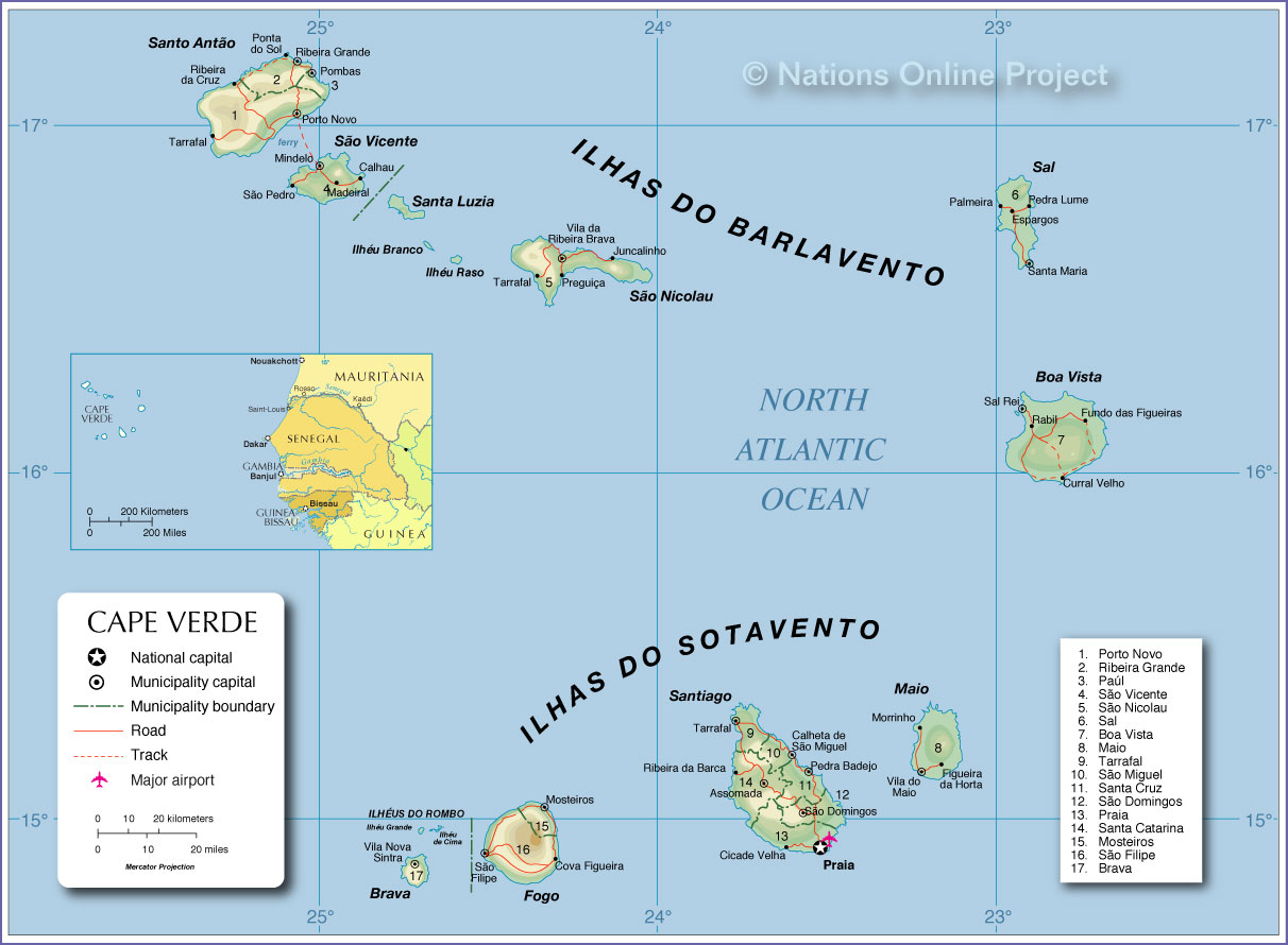
___ Administrative Map of Cape Verde |
|
Cape Verde is an island country in Africa that consists of a group of islands in the Atlantic Ocean 660 km off the coast of Senegal, named after the most western cape in Africa. The archipelago is divided into two island groups, the Barlavento (windward) islands with the islands of Santo Antão, São Vicente, Santa Luzia, São Nicolau, Sal, and Boa Vista and the Sotavento (leeward) islands with the islands of Maio, Santiago, Fogo, and Brava. Map is showing the islands of Cape Verde with municipality boundaries, the national capital Praia, municipality capitals, major towns, main roads, and the airport. Countries with maritime borders are: Gambia, Guinea-Bissau, Mauritania, and Senegal. Related countries: Portugal. Cape Verde was previously uninhabited, the islands were settled by the Portuguese from the 15th century and later served as one of the trading centers for African slaves. Cape Verde remained a Portuguese colony until 1975, when an independent republic was established. |
 Bookmark/share this page |
 One World - Nations Online All Countries of the World |
|
|
||
 Administrative Map of Cape Verde |
|||||||
| Administrative divisions of Cape Verde Cape Verde has 22 municipalities (in Portuguese: concelhos), which are subdivided into 32 parishes (in Portuguese: freguesias). Administrative divisions listed and numbered according to the map: 1. Porto Novo, 2. Ribeira Grande, 3. Paúl, 4. São Vicente, 5. São Nicolau, 6. Sal, 7. Boa Vista, 8. Maio, 9. Tarrafal, 10. São Miguel, 11. Santa Cruz, 12. São Domingos, 13. Praia, 14. Santa Catarina, 15. Mosteiros 16. São Filipe, 17. Brava |
More about Cape Verde: Cities: Country: Continent: |
Praia Weather Conditions
|
Related Consumer Information: |
||||
Political Maps of Countries in West Africa: Benin Map | Burkina Faso Map | Côte d'Ivoire Map | Ghana Map | Guinea Map | Guinea-Bissau Map Liberia Map | Mali Map | Mauritania Map | Niger Map | Nigeria Map | Senegal Map | Sierra Leone Map | Togo Map |
|||||||
One World - Nations Online .:. let's care for this planet Every nation is responsible for the current state of our world. |
| Site Map
| Information Sources | Disclaimer: Privacy Policy, etc. Contact: [email protected] | Copyright © 1998-2021 :: nationsonline.org |
