
|
|
___ Political Map of Ghana |
|
The Map shows Ghana, a country in West Africa, bordered by the Gulf of Guinea in south, Cote d'Ivoire (Ivory Coast) in west, Burkina Faso in north, and Togo in east. An estimated population of 27 million people live in Ghana in 2014. With an area of 238,533 km², the nation is slightly smaller than the UK, or slightly smaller than the U.S. state of Oregon. The country's terrain consists mostly of low plains with low hills. Mount Afadja (or Mount Afadjato) is Ghana's highest elevation with of 885 m (2,904 ft). The mountain is located in the Agumatsa Range east of Lake Volta, the world's largest artificial lake. The Volta River, Ghana's primary river system is formed by the confluence of the Black Volta and the White Volta. The river flows then generally southward through the country and discharges into the Gulf of Guinea. Other main tributaries are the Afram and the Oti River. The Oti is also known as the Pendjari River, it discharges into the Lake Volta reservoir. Map is showing Ghana and the surrounding countries with international borders, region boundaries, the national capital Accra, region capitals, major cities, main roads, and airports. Ghana is a divided into 10 regions: Ashanti Region, Capital: Kumasi | Brong Ahafo Region, Capital: Sunyani | Central Region, Capital: Cape Coast | Eastern Region, Capital: Koforidua | Greater Accra Region | Northern Region, Capital: Tamale | Upper East Region, Capital: Bolgatanga | Upper West Region, Capital: Wa | Volta Region, Capital: Ho | Western Region, Capital: Sekondi-Takoradi |
 Bookmark/share this page |
 One World - Nations Online All Countries of the World |
|
|
||
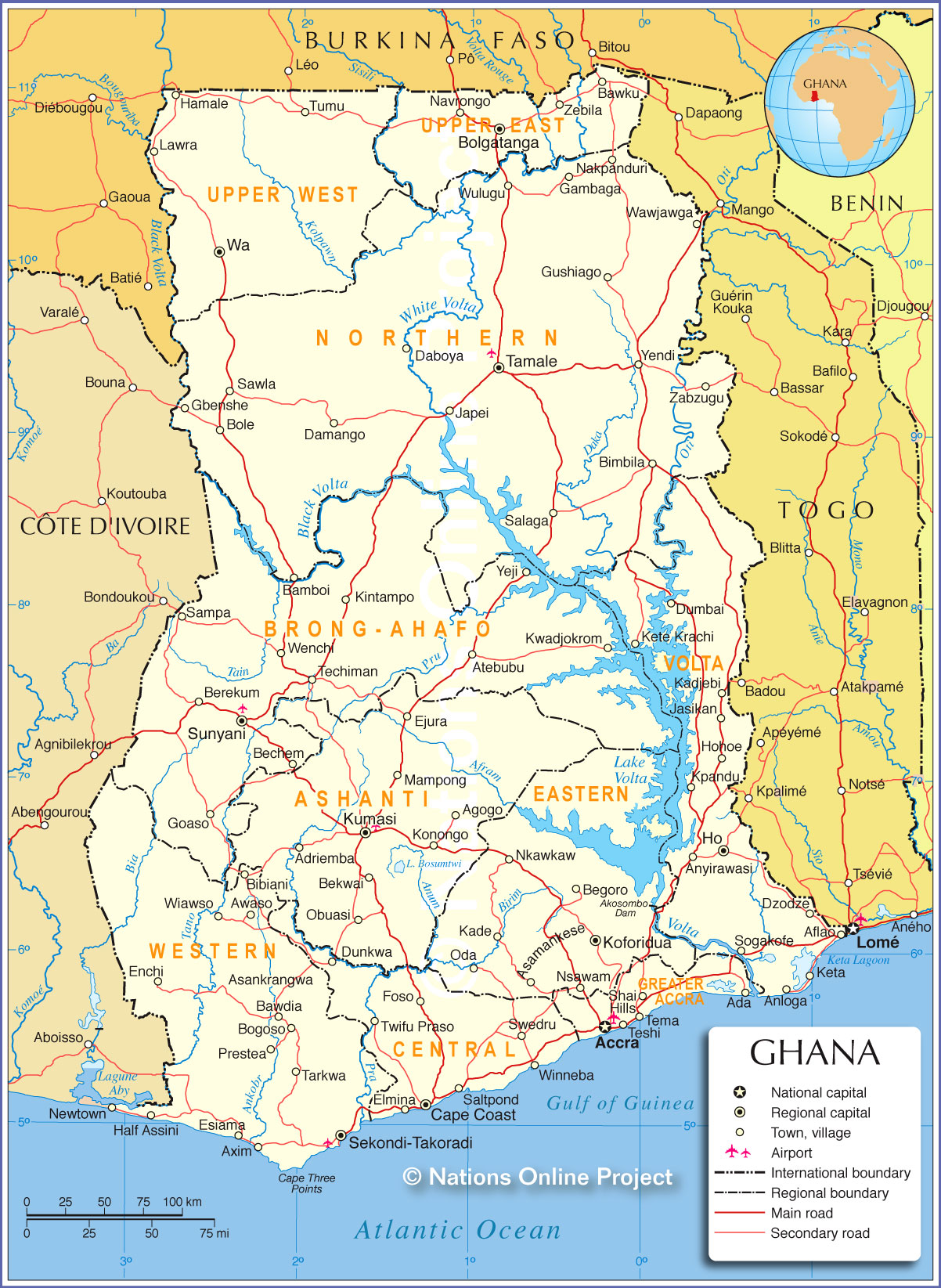 Political Map of Ghana Map based on a UN map. Source: UN Cartographic Section | |||||||
| Cities and Towns in Ghana Map shows the location of following cities and villages in Ghana: Largest cities in Ghana are: Accra (largest city and capital; pop.: 2,3 million), Kumasi (second largest city and capital of Asanteman (Ashanti); pop.: 2 million), Tamale ( capital of the Northern Region; pop.: 560,000), Sekondi-Takoradi (the twin cities of Sekondi and Takoradi are the capital of the Western Region; Sekondi has an artificial harbor and was the first modern port built in Ghana; pop.: about 500,000). Other major cities are Tema, Tamale, and Cape Coast (capital of Central Region). Other cities and towns in Ghana: Ada, Adriemba, Aflao, Agogo, Anloga, Anyirawasi, Asamankese, Asankrangwa, Atebubu, Awaso, Axim, Bamboi, Bawdia, Bawku, Bechem, Begoro, Bekwai, Berekum, Bibiani, Bimbila, Bogoso, Bole, Bolgatanga, Daboya, Damango, Dumbai, Dunkwa, Dzodze, Ejura, Elmina, Enchi, Esiama, Foso, Gambaga, Gbenshe, Goaso, Gushiago, Half Assini, Hamale, Ho, Hohoe, Japei, Jasikan, Kade, Kadjebi, Keta, Kete Krachi, Kintampo, Koforidua, Konongo, Kpandu, Kumasi, Kwadjokrom, Lawra, Mampong, Nakpanduri, Navrongo, Newtown, Nkawkaw, Nsawam, Obuasi, Oda, Prestea, Salaga, Saltpond, Sampa, Sawla, Shai Hills, Sogakofe, Sunyani, Swedru, Tarkwa, Techiman, Teshi, Tumu, Twifu Praso, Wa, Wawjawga, Wenchi, Wiawso, Winneba, Wulugu, Yeji, Yendi, Zabzugu, and Zebila. |
More about Ghana: Cities: Country: Continent: |
Accra Current Weather Conditions
|
Explore More:
Related Consumer Information:
|
||||
Political Maps of other Countries in West Africa: Benin Map | Burkina Faso Map | Cape Verde Map | Côte d'Ivoire Map | Guinea Map | Guinea-Bissau Map Liberia Map | Mali Map | Mauritania Map | Niger Map | Nigeria Map | Senegal Map | Sierra Leone Map | Togo Map |
|||||||
One World - Nations Online .:. let's care for this planet Every nation is responsible for the current state of our world. |
| Site Map
| Information Sources | Disclaimer: Privacy Policy, etc. Contact: [email protected] | Copyright © 1998-2021 :: nationsonline.org |
