Nations Online
All Countries in the World
capital of (Western) Samoa
.
Apia\'s Faleolo Airport serves most international traffic. IATA code: APW
.
Nations Online All Countries in the World | |
Home  |
___ Satellite View and Map of the City of Apia, (Western) Samoa |
About ApiaSatellite view is showing Apia, capital of Samoa. The city is located on the northern coast of Upolu, the smaller one of Samoa's two large islands.Apia is the major financial and business center of the country, the city has a population of about 38,000 people. Modern Apia was founded in the 1850s and has been the capital of Samoa since 1959. Official languages in Samoa are Samoan and English. The map shows a city map of Apia with main roads and other locations, zoom out to find the location of Faleolo International Airport (IATA code: APW). To find a location use the form below. To view just the map, click on the "Map" button. |
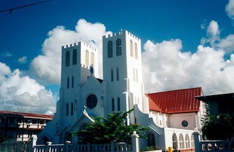 Apia cathedral. Image: Sardon |
| To find a location type: street or place, city, optional: state, country. |
Local Time Samoa:
Wednsday-April-24 14:39
UTC/GMT -11 hoursDST from end of September until beginning April |
|
φ Latitude, λ Longitude (of Map center; move the map to see coordinates): , |
||||||
| Google Earth: Satellite View of Apia, capital of the Independent State of Samoa. |
||||||
| City Coordinates: Coordinates: 13°50′S 171°45′W |
||||||
| More about Samoa: External links: Wikipedia: Apia | Current Weather Conditions Apia at Faleolo International Airport
|
Related Consumer Information:
|
||||
Other Polynesian Island Nations and Territories: American Samoa, Cook Islands, French Polynesia (Tahiti), Niue, Pitcairn, Tonga, Tuvalu |
||||||
| Countries and territories of Australia/Oceania Countries of the World: A - C | D - G | H - L | M - P | Q - T | U - Z Continents: Africa | The Americas | Asia | Europe |
||||||
Map Help [ show ] |
||||||
One World - Nations Online .:. let's care for this planet Promote that every nation assumes responsibility for our world. Nations Online Project is made to improve cross-cultural understanding and global awareness. More signal - less NOISE |
| Site Map
| Information Sources | Disclaimer | Copyright © 1998-2023 :: nationsonline.org |

