Nations Online
All Countries in the World
Nations Online All Countries in the World | |
Home  |
___ Searchable Map and Satellite View of Los Angeles (CA) |
 Downtown L.A. before sunset. Image: Thomas Pintaric |
About Los Angeles |
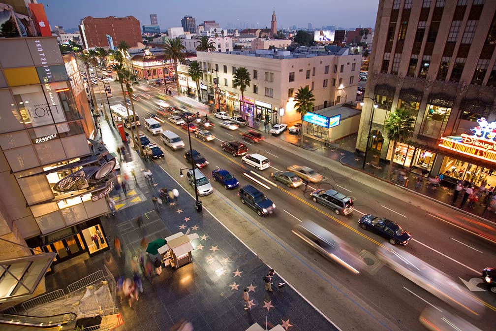
 The satellite view shows Los Angeles, the sprawling Southern California city, largest urban area in the state and the second most populous city in the The satellite view shows Los Angeles, the sprawling Southern California city, largest urban area in the state and the second most populous city in the  The world famous Hollywood Sign, the iconic letters atop Mount Lee in the Hollywood Hills area. Hollywood is a neighborhood in Los Angeles. Photo: raindog808 100 years later after the completion of the Southern Pacific Railroad line to Los Angeles in 1876 the population has grown to more than 10,000 people. Today Los Angeles has a population of about 4 million inhabitants. 18.5 million live in the Greater Los Angeles Area (in 2015), Greater Los Angeles is the second-largest urban region in the United States. Within the Los Angeles–Long Beach–Anaheim MSA area are about 50 cities and towns, the largest are Long Beach, Anaheim, Santa Ana, Irvine, Glendale, and Huntington Beach. Hollywood, a district in the central LA, is known as the original movie mecca, the majority of US movie studios are headquartered in Los Angeles. The city is home to the Kodak Theatre, today known as Dolby Theatre, located close to Hollywood Boulevard in the Hollywood district of Los Angeles. The theater is home of the annual Academy Awards Ceremonies (The Oscars), which were first held there in March 2002, it is the first permanent home for the awards. More points of interest in LA: Hollywood Boulevard, with the famous Hollywood Walk of Fame, more than 2,500 stars bearing the biggest names in the entertainment industry on its sidewalks. Disneyland, the "original", now named Disneyland Park, a must for Disney aficionados. La Brea Tar Pits and Hancock Park, titans of the ice age, fossil excavation site with an adjacent museum and a recreated prehistoric garden. Natural History Museum of Los Angeles County (4.5 billion years of history); Hollywood Bowl (live music); Universal Studios Hollywood (film studio and movie-themed amusement park); Getty Center and J. Paul Getty Museum (fine arts); Museum of Contemporary Art (fine contemporary art); Griffith Park (urban park) with the Griffith Observatory (observatory, exhibit hall, and planetarium); Muscle Beach, Santa Monica (birthplace of the physical fitness boom in the US). Just zoom in (+) to see LA City Hall, the center of the government of the city of Los Angeles and until 1964 the tallest building in Los Angeles. The page shows a city map of Los Angeles with expressways, main roads, and streets, zoom out to find Los Angeles International Airport (IATA code: LAX), located in southwestern Los Angeles near Inglewood, distance from downtown: 18 mi (29 km), and the location of LA/Ontario International Airport, 40 mi (64 km) by road in Ontario, San Bernardino County. To find a location use the form below. To view just the map, click on the "Map" button. |
|
| To find a location type: street or place, city, optional: state, country. |
Local Time Los Angeles:
Thursday-April-25 00:11
Standard time zone Pacific Standard Time (PST): UTC/GMT -8 hoursPacific Daylight Time (PDT) in use from the second Sunday in March, ends on the first Sunday in November; time zone offset: UTC/GMT -7 hours |
|
φ Latitude, λ Longitude (of Map center; move the map to see coordinates): , |
||||||
| Sorry! Google's pricing policy has made it impossible for us to continue showing Google Maps. We apologize for any inconvenience. Google Map: Searchable Map of the City of Los Angeles, California, USA. City Coordinates: 34°03′N 118°15′W |
Bookmark/share this page |
|||||
| More about California and the USA: Other major Cities in California: California State: U.S. States: Country: Continent: |
Weather Conditions Los Angeles
External Links: Los Angeles (official city website) Los Angeles (the official guide) Los Angeles Times A major US newspaper. Wikipedia: Los Angeles |
Related Consumer Information:
|
||||
One World - Nations Online .:. let's care for this planet Promote that every nation assumes responsibility for our world. Nations Online Project is made to improve cross-cultural understanding and global awareness. More signal - less NOISE |
| Site Map
| Information Sources | Disclaimer | Copyright © 1998-2023 :: nationsonline.org |