Nations Online
All Countries in the World
Nations Online All Countries in the World | |
Home  |
___ Satellite View and Map of the City of Oranjestad, Aruba |
About OranjestadSatellite view is showing Oranjestad (en: Orange City), the territorial capital ofOranjestad is the most important city on the island with a population of about 100,000 inhabitants. Official languages are Dutch and Papiamento. The city is named after the first King Willem van Oranje-Nassau (William of Orange-Nassau) - the first heir to the Royal Dutch House of Orange. Some points of interest are: the National Archaeological Museum Aruba, Fort Zoutman (fortification), SS Antilla (wreck), Palm Island (beach and a water park), Eagle Beach and Druif Beach, Arikok National Park and Hooiberg (volcano). The map shows a city map of Oranjestad with expressways, main roads and streets, zoom out to find the location of Queen Beatrix International Airport (IATA Code: AUA). To find a location use the form below. |
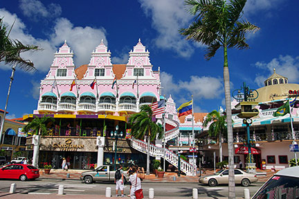 Royal Plaza Shoppingmall, Oranjestad, Aruba Image: Bgabel Bookmark/share this page |
| To find a location type: street or place, city, optional: state, country. | Local Time Aruba:
Saturday-April-20 08:06
UTC/GMT -4 hours |
One World - Nations Online .:. let's care for this planet Promote that every nation assumes responsibility for our world. Nations Online Project is made to improve cross-cultural understanding and global awareness. More signal - less NOISE |
| Site Map
| Information Sources | Disclaimer | Copyright © 1998-2023 :: nationsonline.org |

