Nations Online
All Countries in the World
Nations Online All Countries in the World | |
Home  |
___ Satellite View and Map of the City of Yokohama (横浜市), Japan |
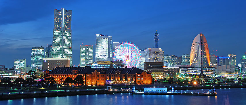 Minato Mirai 21, a large urban development and the central business district in Yokohama City, with Red Brick Warehouse complex, Landmark Tower (Japan's second tallest skyscraper) and the Cosmo Clock 21 (ferris wheel). Photo: akumach |
About Yokohama Satellite view showing Yokohama, a major seaport and the second largest city in Japan. Satellite view showing Yokohama, a major seaport and the second largest city in Japan.The capital city of Kanagawa Prefecture is located about 30 km (18 mi) south of Tokyo, on Tokyo Bay in the Kantō region on the southern side of the island Honshu, Japan's main island. Yokohama, officialy the City of Yokohama, is one of the 15 Japanese Government-designated cities. A designated city (指定都市) is a Japanese city that has a population with more than 500,000 people and has been designated as such by the government.  Yokohama Bay Bridge seen from Yokohama harbor. The flags in foreground show the symbol of Yokohama (left) and the Japanese national flag. Image: Stéfan Today Yokohama has a population of about 3.7 million inhabitants (2015). The cities of Chiba, Kawasaki, Sagamihara, Saitama, Tokyo, and Yokohama constitute the Combined Urban Area of Greater Tokyo, the world's most populous metropolitan area with nearly 38 million people, this is almost one-third of Japan's population. The city of Yokohama is a major commercial hub of the Greater Tokyo Area with shipping, biotechnology, and semiconductor industries. Multinational carmaker Nissan moved its headquarters to Yokohama in 2010. The map shows a city map of Yokohama with expressways, main roads and streets, and the location of the nearest airports to Yokohama, Tokyo International Haneda Airport To find a location use the form below. |
|
| To find a location type: street or place, city, optional: state, country. |
Local Time Yokohama:
Friday-April-19 19:51
UTC/GMT +9 hours |
|
φ Latitude, λ Longitude (of Map center; move the map to see coordinates): , |
||||||
| Google Earth: Searchable Map and Satellite view of Yokohama, Kanagawa Prefecture, Japan. City Coordinates: 35°27′N 139°38′E |
Bookmark/share this page |
|||||
| More about Japan: Landmarks: Mount Fuji Cities: Searchable map/satellite view of Japan's largest cities: Country: Continent: |
Weather Conditions Yokohama Weatherstation at Tamagawaen, Oota-ku, Tokyo
External Links: Yokohama (official city web site) Wikipedia: Yokohama |
Related Consumer Information:
|
||||
| Major Cities in Eastern Asia Bangkok, Beijing, Busan, Chongqing, Colombo, Delhi, Fukuoka, Guangzhou, Hanoi, Ho Chi Minh City, Hong Kong, Islamabad, Jakarta, Karachi, Kobe, Kolkata, Kuala Lumpur, Kyoto, Lahore, Lhasa, Macao, Manila, Mumbai, Nagoya, Osaka, Phnom Penh, Pyongyang, Sapporo, Seoul, Shanghai, Shenzhen, Singapore, Taipei, Tianjin, Tokyo, Ulaanbaatar, Yangon, Yokohama |
||||||
Map Help [ show ] |
||||||
One World - Nations Online .:. let's care for this planet Promote that every nation assumes responsibility for our world. Nations Online Project is made to improve cross-cultural understanding and global awareness. More signal - less NOISE |
| Site Map
| Information Sources | Disclaimer | Copyright © 1998-2023 :: nationsonline.org |

