About Tunisia
The map shows Tunisia, one of the five Maghreb countries in North Africa. Tunisia is situated between
Algeria and
Libya, bordering the
Mediterranean Sea and extends south into the Sahara Desert. The country shares a maritime border with
Italy.
Tunisia occupies an
area of 163,610 km², making it the smallest country in Northern Africa; it is about two-thirds the size of the
United Kingdom, or slightly larger than the US state of
Georgia.
Tunisia has a
population of
11.7 million people (in 2020); the capital, main port and largest city is
Tunis. The vast majority of the population lives in the northern half of the country and along the east coast.
Spoken
languages are Tunisian Arabic, Berber, French (in administration, commerce and education) and English (in tourism).
Official Religion is Islam.
Ten years ago, the Arab Spring began in Tunisia. After ousting a longtime autocrat from power in 2011, Tunisia started a democratic transition, and citizens now enjoy unprecedented political rights and civil liberties.
[FH]
More about Tunisia
Tourism
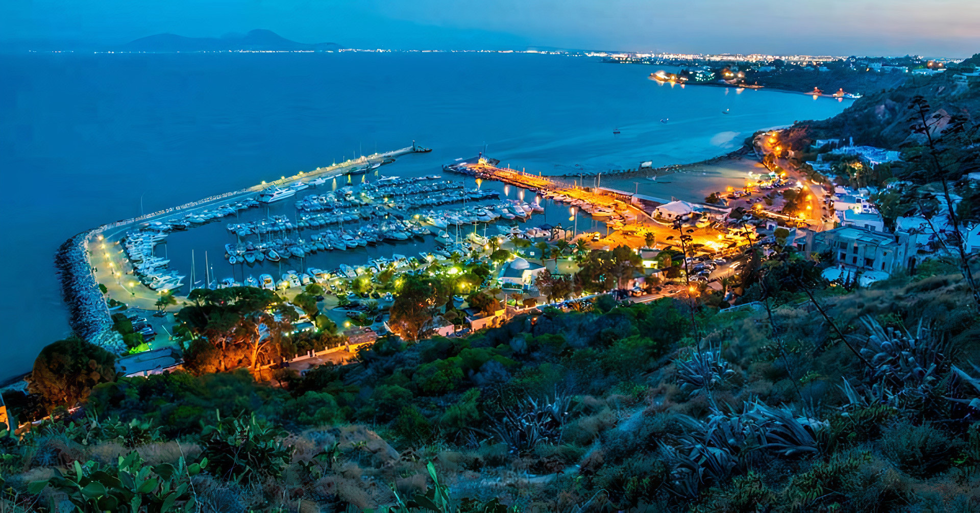
 Sidi Bou Said is a tourist attraction in northern Tunisia, located just northeast of ancient Carthage, once the seat of the powerful Carthaginian (Punic) Empire. The town is known for its blue and white colored architecture.
Image: Nayrouzzz
Despite several terrorist incidents in Tunisia, the country has been a popular tourist destination since the early 1960s and is one of the most visited countries in Africa.
Tourism represents about 16% of Tunisia's GDP (in 2019) and is a major source of foreign currency.
Major tourist destinations are Tunis, Djerba (island), Sidi Bou Said, Kairouan, Tozeur, Hammamet, Monastir and Sousse.
The main attractions are the ancient city of
Carthage near Tunis, and the famous
Amphitheater of El Jem near Sousse.
Geography of Tunisia
The northernmost country of Africa
is the smallest nation in the Maghreb. It borders the
Mediterranean Sea to the north and east.
 The Ribat of Monastir is the oldest ribat (an Arabic fortification) built by the Arab conquerors during the Muslim conquest of the Maghreb in the 8th century AD.
Image: Ad Meskens
In the east, along Tunisia's eastern Mediterranean coast, is a broad coastal plain, known as the
Tunisian Sahel (Al-Sāḥil); the region extends south of the city of Hammamet along the Gulf of
Hammamet to
Mahdia and further south into the
Sfax governorate. The Sahel is famous for its Olive and Almond cultivation.
Mountains
Tunisia's northern landscape is mountainous and dominated by several branches of the eastern Atlas Mountains, the hilly
Tunisian Tell to the north, and the eastern portion of the
Aurès Mountains, also known as the Tabassah Mountains, to the south.
The highest point in the country, with 1,544 m, is
Jebel ech Chambi. The massif, part of the
Aurès or Tabassah Mountains, is located about 14 km northwest of the city of
Kasserine in west-central Tunisia near the border with Algeria. UNESCO designated Jebel ech Chambi as a biosphere reserve in 1977.
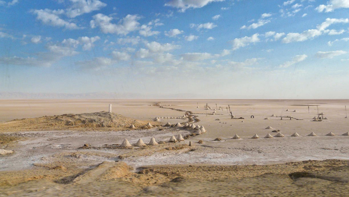
 Small salt mounds in the Chott el Djerid, a salt lake in west-central Tunisia; it is the largest salt pan in the Sahara Desert.
Image: Daniel PERRIES
South of the mountains, the terrain slopes across a plateau to an endorheic basin with several salt lakes and scattered date palm oases.
The
Chott el Djerid, a large salt lake in west-central Tunisia, is the largest salt pan in the Sahara Desert. To the south lies a hot and dry central plain, the semiarid area merges into the
Sahara.
The Sahara
South of the salt lakes stretches the
Grand Erg Oriental, the eastern part of the "Sea of Sand," an area of wind-formed dunes that cover much of east-central Algeria and the southwestern part of Tunisia.
The world's largest (hot) desert covers much of North Africa; it extends from the Atlantic Ocean in the west to the Mediterranean Sea in the north and the Red Sea in the east.
Douz, a town in a palm oasis in the Kebili Governorate in southern Tunisia, is the gateway to the desert.
Douz is known as the host of the annual
International Festival of the Sahara. The
Camel festival is a four-day celebration of traditional desert culture.
About 30 km south of the town is Tunisia's largest national park, the
Jebil National Park, a vast barren desert landscape of the Sahara. The park can be visited on guided safari tours, but is more of a reserve to save the local population of Dorcas gazelle and Addax antelope from extinction than a tourist attraction.
Natural resources of Tunisia
Besides tourism, Tunisia has two major natural resources, petroleum and phosphate.
Natural hazards in Tunisia
Tunisia is subject to a range of natural hazards, including floods, drought, earthquakes, landslides, forest fires, sand encroachments (dunes), dust storms, and sometimes even snowstorms in the north.
[World Bank]
Environmental issues in Tunisia
A major problem in North African countries is desertification and sand encroachment. Poor farming practices, such as overgrazing, deforestation, soil erosion, and a limited supply of natural freshwater sources, contribute to the problem. In Tunisia, other problems are added: dangerous pollutants are discharged into the sea, industrial pollution from phosphate refining has led to the ecological destruction of the sea at Chatt Essalam, Gabes.
[DW]
The map shows the location of the following cities, towns:
Largest cities are:
Tunis (capital city), Sfax, Susah (Sousse), Kairouan, Gabès, Banzart (Bizerte), Monastir, Tataouine, Aryanah (Ariana), and Gafsa.
Other cities and towns are:
Aïn Draham, Ben Arous, Ben-Guerdane, Béja, Chebba, Dehibat, Djebel Mdilla, Douz, El Borma, El Hamma, Enfidaville (Enfidha or Dar-el-Bey), Ferryville (Manzil Bū Ruqaybah), Gaafour, Ghardimaou, Ghdamis, Grombalia, Hammamet, Houmt Souk, Jendouba, Kalaa Kebira, Kasserine, Kebili, Kélibia, Le Kef, Mahdia, Manūbah, Manzil Bū Ruqaybah, Matfur, Matmata, Medenine, Mennzel Temine, Menzel Bou Zelfa, Metlaoui, Moknine, Msaken, Nabeul, Nefta, Remada, Sbeitla, Sidi Bouzid, Siliana, Skhira, Soliman, Souk-el Khemis, Tabarka, Tebourba, Thala, Tozeur, Zaghouan, and Zarzis.
Advertisements:


