Nations Online
All Countries of the World
Nations Online All Countries of the World |
|
| Home |
___ Administrative Map of Benin |
| Map is showing the West African country Benin with surrounding nations, states borders, the national capital Porto-Novo, provincial boundaries, province capitals, and main cities. Click on the map to enlarge for a detailed map of Benin. 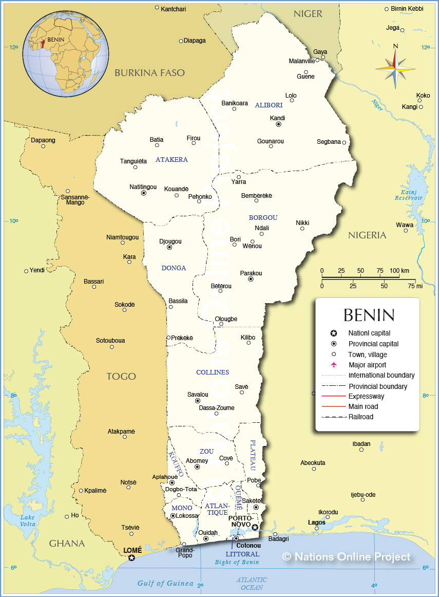 Administrative Map of Benin |
||||||
Benin's administrative divisionsBenin is divided into 12 departments (French: départements), and subdivided into 77 communes.Benin's departments are: In north east Alibori Department with its capital Kandi, a market place and farming center. The department borders three countries, the Mékrou River, a tributary of the Niger River forms part of the border between Alibori and Burkina Faso and between the department and Niger, the Niger River itself forms the other part, in east Alibori is bordered by Nigeria. In north west, in the mountainous region of Benin situated, is Atakora Department with its capital Natitingou, the department borders the Republic of Togo in west. It is home to the Pendjari National Park, known for its wildlife of big game like elephants, lions, hippopotamuses, African buffalo and various antelopes. The Borgou Department is in central east, capital is Parakou, the largest city in eastern Benin, with a population of more than 180,000 people. The commercial town is the hub of Benin's cotton trade. Parakou Railway Station is the northern terminus of the Cotonou-Parakou railway. Donga Department resides in central west of the country, its capital is Djougou, largest city in north west Benin, the city with a population of nearly 200,000 inhabitants is the commercial capital of the Atacora-Donga region and there a major hub of transportation and communication. Collines Department with its capital Savalou, the department in Central Benin is bordered in west by Togo and in east by Nigeria, the Parakou-Cotonou railway runs through it. In October 2010 the normally dry country suffered from a flood, the most devastating in half a century, all regions in south of the country but especially Collines Department has been hit hard by floodwaters triggered by unseasonably heavy rains that caused the Oueme and Mono rivers to overflow. The small Plateau Department with Sakété as its capital town, another main town in the department is Pobè (Ipobe) the small city is the branch railhead of the Eastern Line, of the Cotonou-Pobè railway. Zou Department with Abomey, the "Royal Capital" as its seat of the provincial government. Abomey was formerly the capital of the ancient kingdom of Dahomey (Kingdom of Abomey), including the Republic of Dahomey (1960–1975). The Royal Palaces of Abomey are until now Benin's only UNESCO World Heritage Site. Kouffo Department, since 2008 the small city of Aplahoué is seat of the regional government, before 2008 the capital of Kouffo was Dogbo-Tota or short Dogbo, a major town and marketplace with about 80,000 inhabitants of mainly Aja (Adja) people, who are native to south-western Benin and south-eastern Togo. Mono Department located in the south western corner of Benin, its capital is Lokossa near the border with Togo, a typical West African market town. Atlantique Department's capital is the city of Ouidah on the Atlantic coast, a city of about 90,000 inhabitants. The port city was one of the trading points for the slave trade, all the major colonial powers, who were in need for labor force in their colonial possessions, have built forts in the city to protect their interests in the trade of slaves. The Door of No Return is a memorial to the Atlantic slave trade in Ouidah. In Ouémé Department lies Porto-Novo (also known as Hogbonou and Adjacé) the official capital of the West African nation, which before was the capital of French Dahomey (a French colony from 1904 to 1958). Porto-Novo (Portuguese: New Port) is Benin's second-largest city with a population of about 250,000 inhabitants. It is the seat of the government. Littoral Department is the smallest of Benin's 12 departments, it is just around Benin's largest city Cotonou, cultural and political center of the country. |
Cotonou Current Weather Conditions
|
|||||
More about Benin: Cities: Country: Continent: |
||||||
Bookmark/share this page |
||||||
| Related Consumer Information: |
||||||
One World - Nations Online .:. let's care for this planet Made to improve cross-cultural understanding, global awareness, and cultivating a cosmopolitan consciousness. |
 |
|
| Site Map
| Information Sources | Disclaimer: Privacy Policy, etc. | Contact:
[email protected]
Copyright © 1998-2017 :: nationsonline.org | ||
