Nations Online
All Countries in the World
Nations Online All Countries in the World | |
Home  |
___ Satellite View and Map of the City of Papeete, Tahiti, French Polynesia |
Searchable Map and Satellite View of Papeete using Google Earth DataThe island was proclaimed a colony of France in 1880. Tahiti is located in the middle of nowhere in the South Pacific Ocean, 4,226 km south of Hawaii, 5,956 km west of Brisbane, Australia, 7,756 km east of Lima, Peru. Papeete has a population of about 26,000 inhabitants (2012 census), 134,000 people live in the urban area. Official language is French, but Tahitian and other Polynesian languages are widely in use. Papeete is the primary center of Tahitian and French Polynesian tourism and a frequently used used port of call for cruise ships and yachts. The map shows a city map of Papeete with expressways, main roads and streets, and the location of Tahiti Faa’a International Airport (IATA code: PPT), about 5 km (3 mi) southwest of Papeete. To find a location use the form below. |
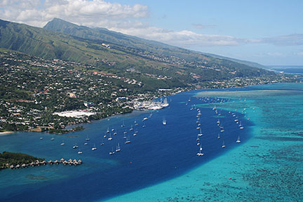 Papeete with Marina Taina Image: Rémi Jouan Bookmark/share this page |
| To find a location type: street or place, city, optional: state, country. |
Local Time Papeete:
Friday-April-26 02:04
Standard Time Zone UTC/GMT -10 hours |
|
φ Latitude, λ Longitude (of Map center; move the map to see coordinates): , |
||||||
| Google Earth: Searchable Map and Satellite view of Papeete, Tahiti, French Polynesia. |
||||||
| City Coordinates: 17°32′06″S 149°34′11″W |
||||||
| More about French Polynesia: Country: Continent: External Link: Ville de Papeete Official website of Papeete (in French). Wikipedia: Papeete Wikipedia entry: Papeete. |
Current Weather Conditions Tahiti
|
Related Consumer Information:
|
||||
Other Polynesian Island Nations and Territories: American Samoa, Cook Islands, Niue, Pitcairn, Samoa, Tonga, Tuvalu |
||||||
Map Help [ show ] |
||||||
One World - Nations Online .:. let's care for this planet Promote that every nation assumes responsibility for our world. Nations Online Project is made to improve cross-cultural understanding and global awareness. More signal - less NOISE |
| Site Map
| Information Sources | Disclaimer | Copyright © 1998-2023 :: nationsonline.org |

