
| Home |
|
|
|
___ Political Map of Haiti | |
About Haiti |
|
| Haiti is a country in the Caribbean Sea that occupies the western third of the island of Hispaniola, it is bordered by the Dominican Republic in east and it shares maritime borders with the Bahamas, Colombia, Cuba, and Jamaica. With an area of 27,750 km², the country is slightly smaller than Albania, or slightly smaller than the U.S. state of Maryland. It is the most mountainous country in the Caribbean, its highest point is Pic la Selle (Chaine de la Selle) with 2,680 m (8,793 ft). Haiti has a population of 10 million people. Capita is Port-Au-Prince. Spoken languages are Haitian Creole and French. Map is showing Haiti on the western part of the island Hispaniola east of |
 Bookmark/share this page |
 One World - Nations Online All Countries of the World |
|
|
||
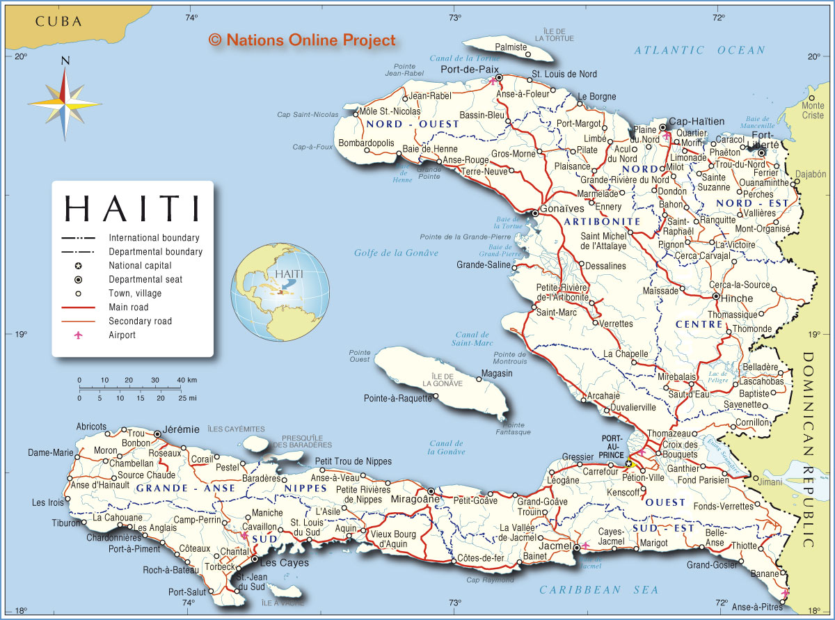 Political and Administrative Map of Haiti Map based on a UN map. Source: UN Cartographic Section |
|||||||
| Cities and towns in Haiti: Map shows the location of following cities and towns in Haiti: Largest Cities: Port-au-Prince (pop.: 900,000), Delmas (Delmas is an urban continuation of the capital Port-au-Prince; pop.: 380,000), Carrefour (pop.: 374,000), Cap-Haïtien (pop.: 200,000). Other cities and villages: Abricots, Acul du Nord, Anse d'Hainault, Anse-à-Foleur, Anse-à-Pitres, Anse-à-Veau, Anse-Rouge, Aquin, Arcahaie, Bahon, Baie de Henne, Bainet, Banane, Baptiste, Baradères, Bassin-Bleu, Belladère, Belle-Anse, Bombardopolis, Camp-Perrin, Caracol, Cavaillon, Cayes-Jacmel, Cerca Carvajal, Cerca-la-Source, Chambellan, Chantal, Chardonnières, Corail, Cornillon, Côteaux, Côtes-de-fer, Croix des Bouquets, Dame-Marie, Dessalines, Dondon, Duvalierville, Ennery, Ferrier, Fond Parisien, Fonds-Verrettes, Fort-Liberté , Ganthier, Gonaïves, Grand-Goâve Trouin, Grand-Gosier, Grande Rivière du Nord, Grande-Saline, Gressier, Gros-Morne, Hinche, Jacmel , Jean-Rabel, Jérémie, Kenscoff, L'Asile, La Cahouane, La Chapelle, La Vallée de Jacmel, La Victoire, Lascahobas, Le Borgne, Les Anglais, Les Cayes, Les Irois, Léogâne, Limbé, Limonade, Magasin, Maïssade, Maniche, Marigot, Marmelade, Milot, Miragoâne, Mirebalais, Mont-Organisé, Morin, Moron, Môle St.-Nicolas, Ouanaminthe, Palmiste, Perches, Pestel, Petit Goâve, Petit Trou de Nippes, Petite Rivière de Nippes, Petite Rivière-de-l'Artibonite, Pétion-Ville, Phaëton, Pignon, Pilate, Plaine du Nord, Plaisance, Pointe-à-Raquette,Port-à-Piment, Port-de-Paix, Port-Margot, Port-Salut, Quartier, Ranquitte, Roch-à-Bateau, Roseaux, Saint Michel de l'Attalaye, Saint-Marc, Saint-Raphaël, Sainte Suzanne, Saut-d'Eau, Savenette, Source Chaude, St. Louis de Nord, St. Louis du Sud, St.-Jean du Sud, Terre-Neuve, Thiotte, Thomassique, Thomazeau, Thomonde, Tiburon, Torbeck, Trou Bonbon, Trou-du-Nord, Vallières, Verrettes, and Vieux Bourg d'Aquin. |
|||||||
| Administrative Divisions of Haiti Map shows the administrative subdivisions of Haiti called departments (provinces). The country is divided into ten departments (departmental capital cities in parentheses). Artibonite (Gonaïves) | Center (Hinche) | Grande-Anse (Jérémie) | Nippes (Miragoâne) | Nord (Cap-Haïtien) | Nord-Est (Fort-Liberté) | Nord-Ouest (Port-de-Paix) | Ouest (Port-au-Prince) | Sud-Est (Jacmel) | Sud (Les Cayes) |
More about Haiti: Cities: Country: Haiti key statistical data. Continent: Reference Map of Central America and the Caribbean. |
Port-au-Prince Current Weather Conditions
|
Related Consumer Information:
|
||||
| Maps of other Countries in Central America: Belize Map, Costa Rica Map, El Salvador Map, Guatemala Map, Honduras, Mexico Map, Nicaragua Map, Panama Map Maps of Caribbean Islands: Cuba Map, Dominican Republic, Jamaica Map, Puerto Rico Map Searchable Maps of Greater Antilles: Cuba, Dominican Republic, Jamaica, Puerto Rico Searchable Maps of Lesser Antilles: Anguilla, Antigua and Barbuda, Aruba, Bahamas, Barbados, Bermuda, Dominica, Grenada, Guadeloupe Martinique, Montserrat, Netherlands Antilles, Saint Kitts and Nevis, Saint Lucia Saint Vincent and the Grenadines, Trinidad and Tobago, Virgin Islands | |||||||
One World - Nations Online .:. let's care for this planet Every nation is responsible for the current state of our world. |
| Site Map
| Information Sources | Disclaimer: Privacy Policy, etc. Contact: [email protected] | Copyright © 1998-2021 :: nationsonline.org |
