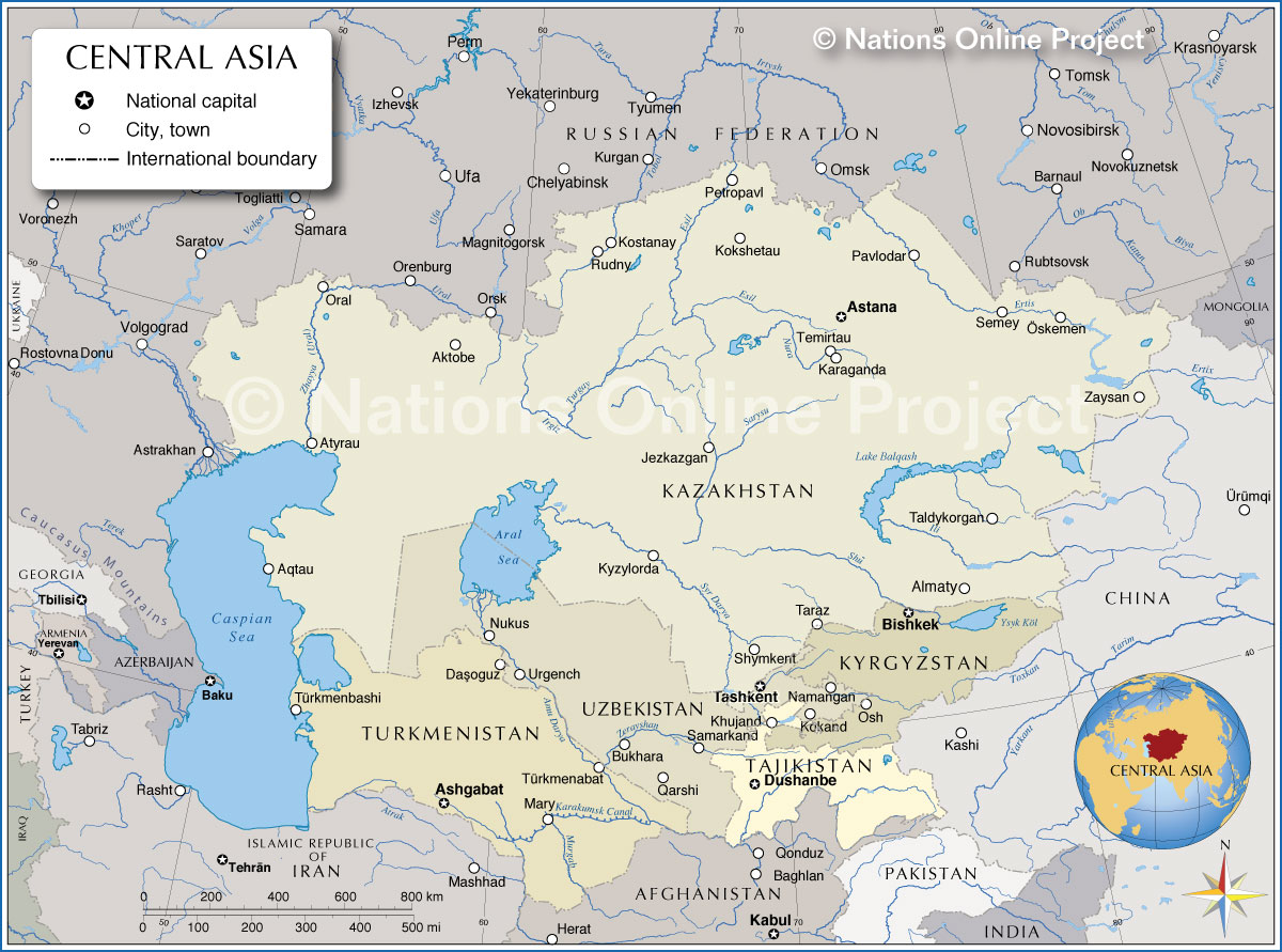
More about Central Asia
 The Pamir Mountains are a mountain range between Central Asia and South Asia, known as the "Roof of the World.
Photo: AmanovDmitry
The Pamir Mountains are a mountain range between Central Asia and South Asia, known as the "Roof of the World.
Photo: AmanovDmitry
Central Asia has long been a crossroads of civilizations — shaped by nomadic cultures,
ancient trade routes like the
Silk Road, and empires that rose and fell across its vast steppes and deserts. Today, the region blends deep traditions with modern statehood, offering a unique mix of
Turkic,
Persian, and
Russian influences.
Countries of Central Asia
Five countries are in Central Asia.
Kazakhstan
The largest country in Central Asia—and the ninth biggest in the world—Kazakhstan stretches from the Caspian Sea to the Altai Mountains. Once a vital part of the Silk Road, today it's a land of futuristic cities like Astana, vast steppes, and space launches from Baikonur. Rich in natural resources, Kazakhstan is a regional powerhouse with a foot in both Europe and Asia.
Uzbekistan
The country is home to the ancient cities of
Samarkand,
Bukhara, and
Khiva. Uzbekistan is Central Asia's cultural heart. The country offers stunning Islamic architecture and a deep historical legacy as a crossroads of civilizations. Modern Uzbekistan is reform-minded and opening up fast, while staying rooted in its traditions.
Kyrgyzstan
Mountainous Kyrgyzstan is a land of nomadic heritage and alpine beauty. The
Tien Shan mountains dominate the landscape, and the spirit of the
Silk Road still lingers in yurt camps and bustling bazaars. Known for its democratic aspirations and rugged independence, Kyrgyzstan offers a striking contrast between wild nature and resilient identity.
 View of the Monument of Akhal-Teke horses in Ashgabat, Turkmenistan's capital city. The Presidential Palace, the official residence of the president of Turkmenistan, is in the background.
Photo: John Pavelka
View of the Monument of Akhal-Teke horses in Ashgabat, Turkmenistan's capital city. The Presidential Palace, the official residence of the president of Turkmenistan, is in the background.
Photo: John Pavelka
Tajikistan is defined by its dramatic terrain—over 90% of the country is mountainous. The
Pamirs, sometimes called "
the Roof of the World," offer some of the most spectacular scenery in Asia. With deep Persian roots, Tajikistan is culturally distinct in the region, and though it faces economic challenges, it remains proud of its rich heritage and breathtaking landscapes.
[UNESCO]
Turkmenistan
Enigmatic and often overlooked, Turkmenistan is a desert nation with a flair for the surreal.
Ashgabat, its marble-clad capital, looks like a futuristic mirage, while the Darvaza gas crater—"
the Door to Hell"—burns in the heart of the
Karakum Desert. Turkmenistan follows its own path, shaped by deep traditions, massive energy reserves, and strict governance.
Landscapes of Central Asia
Central Asia's landscapes offers dramatic contrasts: the towering
Tian Shan and
Pamir Mountains, the vast
Karakum and
Kyzylkum deserts, and major rivers like the
Amu Darya and
Syr Darya, which once fed the now largely vanished
Aral Sea.
To the west lies the
Caspian Sea, the world's largest inland body of water. Scattered across the region are striking lakes such as
Lake Issyk-Kul in Kyrgyzstan,
Lake Balkhash in Kazakhstan, and
Sarez Lake in Tajikistan, formed by a massive earthquake-triggered landslide. Turkmenistan is home to the Darvaza gas crater, known as the Door to Hell — a fiery pit that has been burning since the early 1970s, adding a surreal touch to the desert landscape.
Major geographic features of Central Asia.
 In the Kyrgyz Outlands: Yurts, livestock, and Kyrgyz nomads in a vast mountain landscape. A picture of modern nomadic life where tradition endures on the open pastures.
Photo: Sathish J
In the Kyrgyz Outlands: Yurts, livestock, and Kyrgyz nomads in a vast mountain landscape. A picture of modern nomadic life where tradition endures on the open pastures.
Photo: Sathish J
At the northern edge of Central Asia, this mountain range links Russia, Kazakhstan, Mongolia, and China. Rich in biodiversity and ancient rock carvings, it's often seen as the origin of Turkic peoples.
Tien Shan Mountains
A massive mountain range spanning Kyrgyzstan, Kazakhstan, and western China. Known as the "Mountains of Heaven," the Tien Shan contains some of the highest peaks in Central Asia, including
Jengish Chokusu (Victory Peak) at 7,439 m and
Khan Tengri at 7,010 m.
Pamir Mountains
Called the "Roof of the World," this range in Tajikistan and northeastern Afghanistan connects the
Himalayas,
Karakoram,
Hindu Kush, and the
Tien Shan mountain range. Glaciated and remote, the Pamirs hold strategic passes and ancient Silk Road routes.The highest peak is
Kongur Tagh at 7,649 m.
Ural Mountains
The Ural Mountains in Russia extend from the
Kara Sea in the north to the
Ural River in the
Kazakh Steppe in the south. The 2,500 kilometers (1,550 miles) long mountain range forms the traditional boundary between
Europe in the west and
Asia in the east.
[NASA]
Deserts
 The Yangykala Canyon is located in western Turkmenistan, near the Garabogazköl Basin and the Caspian Sea. Yangykala is a breathtaking landscape of flaming cliffs, wind-sculpted ridges, and layered sedimentary rock.
Photo: Timon91
The Yangykala Canyon is located in western Turkmenistan, near the Garabogazköl Basin and the Caspian Sea. Yangykala is a breathtaking landscape of flaming cliffs, wind-sculpted ridges, and layered sedimentary rock.
Photo: Timon91
The
Karakum Desert ("Black Sand" in Turkic languages) is in Turkmenistan and reaches close to the eastern shores of the
Caspian Sea. The desert's western fringes nearly touch the coastline, influencing its climate and landscape significantly. The desert is famous for extreme aridity, shifting dunes, and the eerie
Darvaza Gas Crater—a fiery pit that's been burning since 1971.
Yangykala Canyon
Located in western Turkmenistan, on the western edge of the Karakum Desert, near the
Garabogazköl Basin and the
Caspian Sea. Yangykala Canyon is a breathtaking landscape of flaming cliffs, wind-sculpted ridges, and layered sedimentary rock. Once part of the Tethys Ocean, the canyon is a fossil-rich window into Earth's geological past.
Kyzylkum Desert
The vast Kyzylkum red-sand desert stretches across Uzbekistan, Kazakhstan, and Turkmenistan. It's a dry, harsh region with scattered oases and mineral-rich soils, flanked by old caravan paths and abandoned Silk Road settlements.
Valleys
Fergana Valley
A fertile, densely populated valley located in the east of Uzbekistan and northern Tajikistan. Surrounded by mountains, it's a historic crossroads of cultures and agriculture, known for its cotton fields and water disputes.
Turgay Basin
The Turgay Basin is a
broad depression in north-central Kazakhstan, stretching between the
Ural Mountains and the
Kazakh Uplands. Shaped by ancient tectonic movements, the basin forms a long, shallow valley running roughly north to south.
Lakes
 Rusting ships stranded in the sand of the dried-up Aral Sea in Kazakhstan.
Photo: © UNESCO - Zhanat Kulenov
Rusting ships stranded in the sand of the dried-up Aral Sea in Kazakhstan.
Photo: © UNESCO - Zhanat Kulenov
Once the world's fourth-largest lake, the Aral Sea between Kazakhstan and Uzbekistan has largely vanished due to Soviet-era projects, such as the diversion of the
Syr Darya and
Amu Darya rivers for irrigation, primarily for cotton farming. It's a haunting symbol of environmental collapse, with ghost towns and rusting ships stranded in sand.
[UN]
Caspian Sea
The Caspian Sea lies at the crossroads of Central Asia, Eastern Europe, and the Caucasus. The eastern Caspian coastline, especially in Kazakhstan and Turkmenistan, is considered part of Central Asia.
Lake Balkhash
Lake Balkhash is located in Kazakhstan; it is the largest lake in Central Asia and fifteenth-largest in the world.
Rivers
Syr Darya River
One of Central Asia's two main rivers, it flows from the
Tien Shan through Uzbekistan and Kazakhstan into the remnants of the
Aral Sea. A vital source of irrigation, though often heavily diverted.
Amu Darya River
The other great river of the region, rising in the
Pamirs and flowing northwest into the
Aral Sea basin. In antiquity, it was known as the Oxus and formed part of the Persian and later the Soviet frontier.