Advertising

China Flag detail
Home Earth Continents Asia China Country Profile Administrative Map of China

Maps Index

Administrative Map of China


The Great Wall of China is a well known landmark in the Middle Kingdom.
A section of the Great Wall of China. Most of the present structure dates to the Ming dynasty (14th century).
Image: Bjoern Kriewald

About China


China Flag
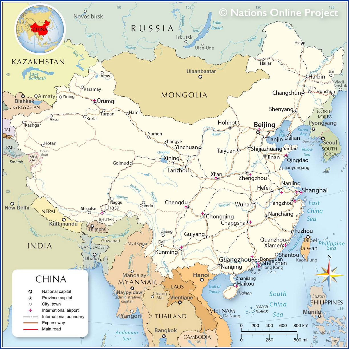
The map shows the provinces of China, officially the People's Republic of China (PRC), a vast country in East Asia. The PRC is bounded by the East China Sea, the Korea Bay, the Yellow Sea, and the South China Sea.

China borders 14 countries: Afghanistan, Bhutan, India, Kazakhstan, North Korea, Kyrgyzstan, Laos, Mongolia, Myanmar (Burma), Nepal, Pakistan, Russia, Tajikistan, and Vietnam. The country shares maritime borders with Japan, South Korea, the Philippines, and Taiwan. Due to China's claims in the South China Sea, the state also maintains overlapping maritime borders with Brunei and Malaysia.

The People's Republic covers an area of 9,597,000 km², making it the fourth largest country on Earth; it is just somewhat smaller than the United States, and 1.25 times the size of Australia.

China has a population of around 1.44 billion people (in 2021),[1] making it the world's most populous country.

 
Administrative Map of China

Map of China with Administrative Divisions, provinces,  autonomous regions and municipalities
Map of China with Administrative Divisions

The map shows China and surrounding countries with international borders, the national capital Beijing, provinces, province-level autonomous regions, province capitals, special administrative regions (S.A.R.), and direct-administered municipalities of China, with names in English and Chinese.

You are free to use above map for educational purposes, please refer to the Nations Online Project.


More about China


China's official map of maritime claims in the South China Sea
China's official map shows its claimed maritime borders in the South China Sea (nine-dash line), and Taiwan as a part of the People's Republic of China.
Image: Courtesy of SinoMaps Press

 
Administrative Divisions

The People's Republic of China is divided into 33 administrative regions, there are 22 provinces, five autonomous regions, four municipalities, and two special administrative regions (SAR).
Additionally, China claims sovereignty over the territory administered by Taiwan (Republic of China ), claiming most of the territory as China's Taiwan Province (台湾省).


List of China's administrative divisions (capitals in parentheses):

Municipalities (Zhixia Shi)
北京 Beijing, 重庆 Chongqing, 上海 Shanghai, and 天津 Tianjin.
These are self-governing districts under the direct jurisdiction of the central government.


Autonomous Regions (Zizhiqu)
An administrative region where the minority (Chinese Han) is the majority in the local government and congress.

广西 Guangxi (Nanning), 内蒙古 Nei Menggu (Inner Mongolia, capital: Hohhot), 宁夏 Ningxia (Yinchuan), 西藏 Xizang (Tibet, capital: Lhasa), 新疆 Xinjiang Uyghur Autonomous Region (Ürümqi)


Special Administrative Regions (Tebie Xingzhengqu, S.A.R.):
香港 Hong Kong, and 澳门 Macau
This Special Administrative Regions pursue the policy of "One Country, Two Systems".


Political Map of China
Political Map of China (click map to enlarge)
Map: © nationsonline.org
 
Provinces (Sheng)
安徽 Anhui (Hefei), 福建 Fujian (Fuzhou), 甘肃 Gansu (Lanzhou), 广东 Guangdong (Guangzhou), 贵州 Guizhou (Guiyang), 海南 Hainan (Haikou), 河北 Hebei (Shijiazhuang), 黑龙江 Heilongjiang (Harbin), 河南 Henan (Zhengzhou), 湖北 Hubei (Wuhan), 湖南 Hunan (Changsha), 江苏 Jiangsu (Nanjing), 江西 Jiangxi (Nanchang), 吉林 Jilin (Changchun), 辽宁 Liaoning (Shenyang), 青海 Qinghai (Xining), 陕西 Shaangxi (Xi'an), 山东 Shandong (Jinan), 山西 Shangxi (Taiyuan), 四川 Sichuan (Chengdu), 云南 Yunnan (Kunming), 浙江 Zhejiang (Hangzhou)


Disputed territorial claims of China in the South China Sea
In addition to China's claim to sovereignty over the territory administered by Taiwan (Republic of China), Beijing claims suzerainty over hundreds of coral islands and reefs of the Spratly (Nansha Qundao 南沙群島; Nansha District of China) and the Paracel Islands (Xisha Qundao 西沙群島; Xisha District of China), the two major archipelagos in the South China Sea.

The People's Republic of China invests millions in infrastructure and development to bolster its territorial claims to the islands in the South China Sea, although neighboring nations such as Vietnam, Brunei, Malaysia and the Philippines have legitimate claims. In 1987, China installed a small military structure on Fiery Cross Reef under the pretext of building an "oceanic observation station."
Since then, China has built numerous military facilities, such as air bases and airfields, and constructed several artificial islands in the South China Sea, primarily to claim waterways and underwater resources. China occupies seven islands (reefs) of the Spratly Group and twenty of the Paracel Islands. [CSIS]
The prefecture-level city of Sansha (Hainan province) on Yongxing Island administers China's occupied island groups, atolls, seamounts and various other maritime features within its nine-dash line (extent of Chinese "historical" claims within the South China Sea).


Weather Conditions Beijing:

BEIJING WEATHER


Advertisements:


Maps of other countries in Southeast and Eastern Asia:
Bangladesh Map, Bhutan Map, Cambodia Map, India Map, Indonesia Map, Japan Map, Korea (North), Korea (South), Laos Map, Malaysia Map, Maldives Map, Mongolia Map, Myanmar Map, Nepal Map, Pakistan Map, Philippines Map, Singapore Map, Sri Lanka Map, Taiwan Map, Thailand Map, Vietnam Map