Nations Online
All Countries in the World
Nations Online All Countries in the World | |
Home  |
___ Satellite View and Map of the City of Erfurt, Germany |
Searchable Map of Erfurt using Google Earth DataSatellite view is showing Erfurt, largest city and the capital of the Free State of Thuringia, a German Federal State (in German: Bundesland).The city is located in the southern part of the Thuringian Basin at Gera river in central Germany, about 190 km west of Dresden. During the Middle Ages Erfurt was an important trading town and until today it has preserved an intact medieval city center. Today Erfurt has a population of about 200,000 inhabitants. The city is connected to the motorways A 4 and A 71 (Bundesautobahn) and is linked to the ICE/IC network of the German Rail. Erfurt Airport (Flughafen Erfurt; IATA code: ERF) connects Thuringia with the rest of the international air traffic network. Erfurt is seat of the University of Erfurt (originally founded in 1392). Just zoom in to see Erfurt Cathedral (Mariendom, in south ) and and Severikirche. The Map shows a city map of Erfurt with expressways, main roads and streets. |
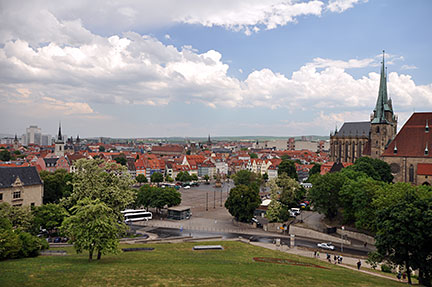 Erfurt city center, panoramic view from Petersberg castle over Domplatz with Dom and Severikirche. Image: Ralf Roletschek |
| To find a location type: street or place, city, optional: state, country. |
Local Time Erfurt:
Sunday-April-28 04:45
Standard Time Zone (CET): UTC/GMT +1 hourCEST (Daylight Saving Time) in use from end of March until end of October. Time zone offset: UTC/GMT +2 hours |
|
φ Latitude, λ Longitude (of Map center; move the map to see coordinates): , |
||||||
| Google Earth: Searchable map and satellite view of Erfurt, Thuringia, Germany. |
||||||
| City Coordinates: 50°59′0″N 11°2′0″E |
||||||
| More about Germany: Landmarks: Searchable map/satellite view of some major cities in Germany: Berlin, Bremen, Dresden, Düsseldorf, Frankfurt, Hamburg, Hannover, Kiel, Köln (Cologne), Magdeburg, Mainz, München (Munich), Potsdam, Saarbrücken, Schwerin, Stuttgart, Wiesbaden Bundesland (State): Country: Continent: External Links Stadt Erfurt Official web site of the city of Erfurt. Wikipedia: Erfurt Wikipedia article about Erfurt |
Current Weather Conditions Erfurt:
|
Related Consumer Information:
|
||||
| Countries and Territories of Europe Countries of the World: A - C | D - G | H - L | M - P | Q - T | U - Z Continents: Africa | The Americas | Asia | Australia/Oceania |
|
Search Nations Online Project
|
Bookmark/share this page
|
One World - Nations Online .:. let's care for this planet Promote that every nation assumes responsibility for our world. Nations Online Project is made to improve cross-cultural understanding and global awareness. More signal - less NOISE |
| Site Map
| Information Sources | Disclaimer | Copyright © 1998-2023 :: nationsonline.org |


