Nations Online
All Countries in the World
Nations Online All Countries in the World | |
Home  |
___ Satellite View of Costa Rica |
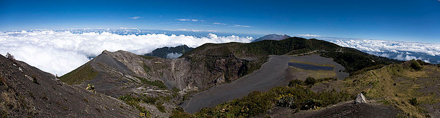 Panorama of Irazu Volcano situated east of San José, it is the highest active volcano in Costa Rica. - Image: Rafael Golan |
Searchable Map and Satellite View of Costa Rica using Google Earth DataSatellite view is showing the Central American country on the Isthmus of Panama, bordering the Caribbean Seain the north-east and the North Pacific Ocean in south-west. It is bordered by Panama in south east and by Nicaragua in north. Costa Rica is known for its beaches, volcanoes and the immense biodiversity of its wildlife rich rainforests. Capital city is San José. Official language is Spanish. More about Costa Rica... The map shows Costa Rica with cities, towns, expressways, main roads and streets. To find a location use the form below. To view just the map, click on the "Map" button. To find a location type: street or place, city, optional: state, country. |
|
| Local Time Costa Rica:
Sunday-April-28 09:44
Standard time zone: Central Standard Time (CST); UTC/GMT -6 hours |
|
|
φ Latitude, λ Longitude (of Map center; move the map to see coordinates): , |
||||||
| Google Maps: Searchable Map/Satellite View of the Republic of Costa Rica. |
Bookmark/share this page |
|||||
| More about Costa Rica: Reference Map of Central America and the Caribbean. |
Current Weather Conditions San José:
|
Related Consumer Information:
|
||||
|
Searchable Maps of other Countries of Central America: Belize, Costa Rica, El Salvador, Guatemala, Honduras, Nicaragua, Panama Country Profiles: Countries and Territories of The Americas |
||||||
Map Help [ show ] |
||||||
One World - Nations Online .:. let's care for this planet Promote that every nation assumes responsibility for our world. Nations Online Project is made to improve cross-cultural understanding and global awareness. More signal - less NOISE |
| Site Map
| Information Sources | Disclaimer | Copyright © 1998-2023 :: nationsonline.org |

