Nations Online
All Countries in the World
Nations Online All Countries in the World | |
Home  |
___ Satellite View and Map of Romania |
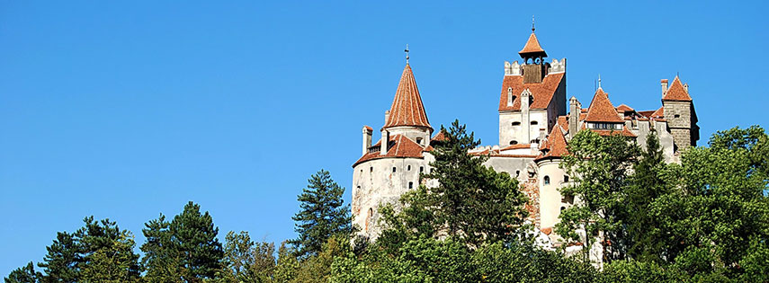 Bran Castle, the fortress is situated on the border between Transylvania and Wallachia and is commonly known as "Dracula's Castle". Image: Snowkite |
About Romania Map view is showing the Southeastern European country, bordering the Black Sea in east. Countries with international borders to Romania are Bulgaria, Hungary, Moldova, Serbia, and Ukraine, it also shares a maritime border with Turkey. Map view is showing the Southeastern European country, bordering the Black Sea in east. Countries with international borders to Romania are Bulgaria, Hungary, Moldova, Serbia, and Ukraine, it also shares a maritime border with Turkey. Pătru's peak (2130 m) in Alba County, seen from the dam of lake Oaşa. Image: Cristi Faur Romania has a population of 20 million people (2014), capital and largest city is Romania's landscapes are partly mountainous and hilly and it has large lowland terrains. Its center is dominated by the Carpathian Mountains, highest point with 2,544 m is Moldoveanu Peak in Argeș County. Romania is home to the largest area of virgin forests in Europe. The map shows main cities and towns, expressways, roads, railroads and airports. To view just the map, click on the "Map" button. To find a location use the form below. |
|
| To find a location type: street or place, city, optional: state, country. |
Local Time Romania:
Monday-June-15 06:17
Standard Time Zone (EET): UTC/GMT +2 hoursDaylight Saving Time in use from end of March until end of October: time zone offset: UTC/GMT +3 hours |
|
φ Latitude, λ Longitude (of Map center; move the map to see coordinates): , |
||||||
| Sorry! Google's pricing policy has made it impossible for us to continue showing Google Maps. We apologize for any inconvenience. Google Map: Searchable map/satellite view of Romania. |
Bookmark/share this page |
|||||
| More about Romania: Cities: Country: Continent: Political Map of the Balkans. |
Weather Conditions Bucharest
|
Related Consumer Information:
|
||||
Maps of other Countries in Southern Europe Albania Map, Croatia Map, Cyprus Map, Greece Map, Italy Map, Macedonia Map Montenegro Map, Portugal Map, Serbia Map, Slovenia Map, Spain Map, Turkey Map, Vatican City State Map Searchable Maps of other Countries in Southern Europe Albania, Bosnia and Herzegovina, Croatia, Cyprus, Greece, Italy, Macedonia Montenegro, Portugal, Serbia, Slovenia, Spain, Turkey, Vatican City State Profiles of other Countries in Southern Europe Albania, Bosnia and Herzegovina, Croatia, Cyprus, Greece, Italy, Macedonia Montenegro, Portugal, Serbia, Slovenia, Spain, Turkey, Vatican City State |
||||||
One World - Nations Online .:. let's care for this planet Promote that every nation assumes responsibility for our world. Nations Online Project is made to improve cross-cultural understanding and global awareness. More signal - less NOISE |
| Site Map
| Information Sources | Disclaimer | Copyright © 1998-2024:: nationsonline.org |
