About Bolivia
The map shows Bolivia, officially the
Plurinational State of Bolivia, the landlocked country in central west
South America. In pre-Columbian times, the region was part of the ancient
Inca Empire. Bolivia is named after independence fighter
Simón Bolívar, who led Bolivia and several other South American countries to independence from Spanish rule in 1825. Democratic civilian rule was established in Bolivia only in 1982, but its leaders have faced problems of deep-seated poverty, social unrest and illegal drug production.
[WFB]
Bolivia borders
Argentina,
Brazil,
Chile,
Paraguay and
Peru. With an
area of 1,098,581 km² (424,164 sq mi), the country is about twice the size of
Spain or about three times the size of the U.S. state of
Montana.
Bolivia has a
population of 12.2 million people (est. 2023). The population of Bolivia is mainly mestizo (Spanish and indigenous Indian descent, 68%), Quechua, Aymara people and about 35 indigenous groups making up the minorities (averaging 0.3% per group).
Two capitals
The country is one of the few states with two capitals:
La Paz (officially: Nuestra Señora de La Paz) is the seat of the national government (executive, legislative, and electoral bodies) and
Sucre, which is the legal capital and the seat of the judiciary.
Official
language is Spanish, spoken by about 60% of the population; spoken indigenous languages are Aymara, Quechua, Guaraní and more than 30 other native languages. The major religions in Bolivia are the Catholic Church (82%), Evangelicalism (11%), and Protestantism (3%).
More about Bolivia
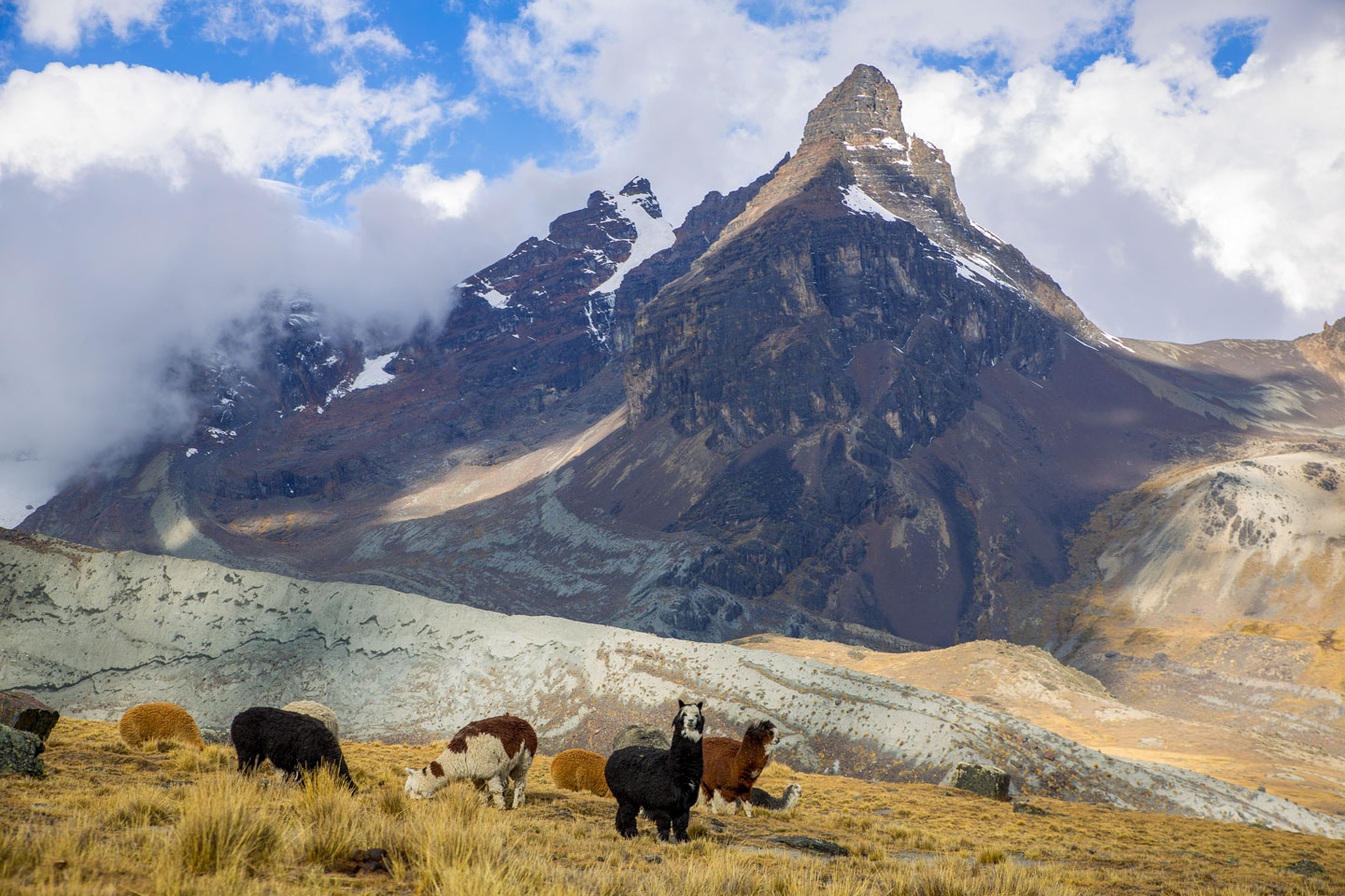
 A herd of llamas near Aguja Negra mountain in the Kunturiri (Condoriri) massive in the Cordillera Real, north of La Paz. Bolivia is home to four species of camelids, llamas, alpacas, guanacos and vicuñas.
Photo: Havardtl
Bolivia has been a landlocked country since the
War of the Pacific (1879-1904); in 1904, it lost its Pacific port cities of
Mejillones and
Antofagasta to Chile.
Bolivia's main geographical regions
Bolivia is divided into a number of very different geographical regions.
- In the southwest, one-third of the country is dominated by the Bolivian portion of the world's largest mountain range, the Andes.
- The Altiplano, or Andean Plateau, is an endorheic (no water outflow) high plateau in southeastern Peru and western Bolivia between the high mountain ranges of the West Andes (Cordillera Occidental) and the East Andes (Cordillera Oriental). The country's administrative capital, La Paz, is located on the northeastern edge of the plateau. The vast plateau is home to Lake Titicaca and the Salar de Uyuni and Coipasa salt flats. The plateau is endorheic, meaning there is no runoff, and most water from the lakes and rivers evaporates.
-
 A "Queen of the Andes" plant (Puya raimondii) near the municipality of Vacas in the Cochabamba Department of Bolivia. Puya raimondii is the largest known species of bromeliad and reaches a height of 3 m with a flower spike of 9-10 m high.
Image: Wilmer
- The Puna region of the Central Andes is a high-altitude montane grassland in the west of the West Andes (Cordillera Occidental); it extends from southern Peru, through southwestern Bolivia, into northern Argentina and Chile. The large area of the Puna comes in different varieties, the humid Puna, Puna Húmeda, around Lake Titicaca; the semi-humid Puna, Puna Subhúmeda, an arc-shaped region north of Lake Poopó; the dry Puna, Puna Seca, to the south of the lake in the region of the salt flats of Coipasa and Uyuni, and the desert-like Puna, Puna Desértica in the southwestern corner of the country.
- The highland valleys of the Bolivian Yungas are a transition zone between the high mountains of the Andes and the lowlands of the Amazon basin, a tropical and subtropical ecoregion on the eastern slopes of Bolivia's Andes.
- More than 35% of Bolivia's area is covered by tropical Amazon rainforest in the Bolivian Amazon region in the northern part of the country. The vast Amazon Basin, the drainage basin of the Amazon River, is shared by eight countries, Bolivia, Brazil, Colombia, Ecuador, Guyana, Peru, Suriname, and Venezuela.
- The lowlands. The year-round hot and humid eastern lowlands encompass Bolivia's territory north and east of the Andes. The largest portion of the country consists of the tropical lowlands of the Parana and Amazon basins. The region in the north of the country is known as the Bolivian Amazon; the rainforest-covered area is home to abundant wildlife. Parts of the Brazilian Pantanal wetland extend into Bolivia in the southeast.
Within the northeastern part of Bolivia are the Moxos Plains (Llanos de Moxos), also known as Beni Savanna, a 120,000 km² large tropical savanna and wetland ecosystem in the southwestern Amazon basin. It is a confluence zone of four South American biogeographic regions: the Amazon, the Cerrado, the Chiquitanía and the Chaco.
- The Bolivian part of the Gran Chaco (Quechua: "hunting land") is located in the southeast of the country. The alluvial plain of the Río de la Plata basin in the interior of South America is an arid, subtropical and sparsely populated region with savannas and low canopy forests, fed by only two rivers, the Paraguay and Paraná rivers.
Mountains
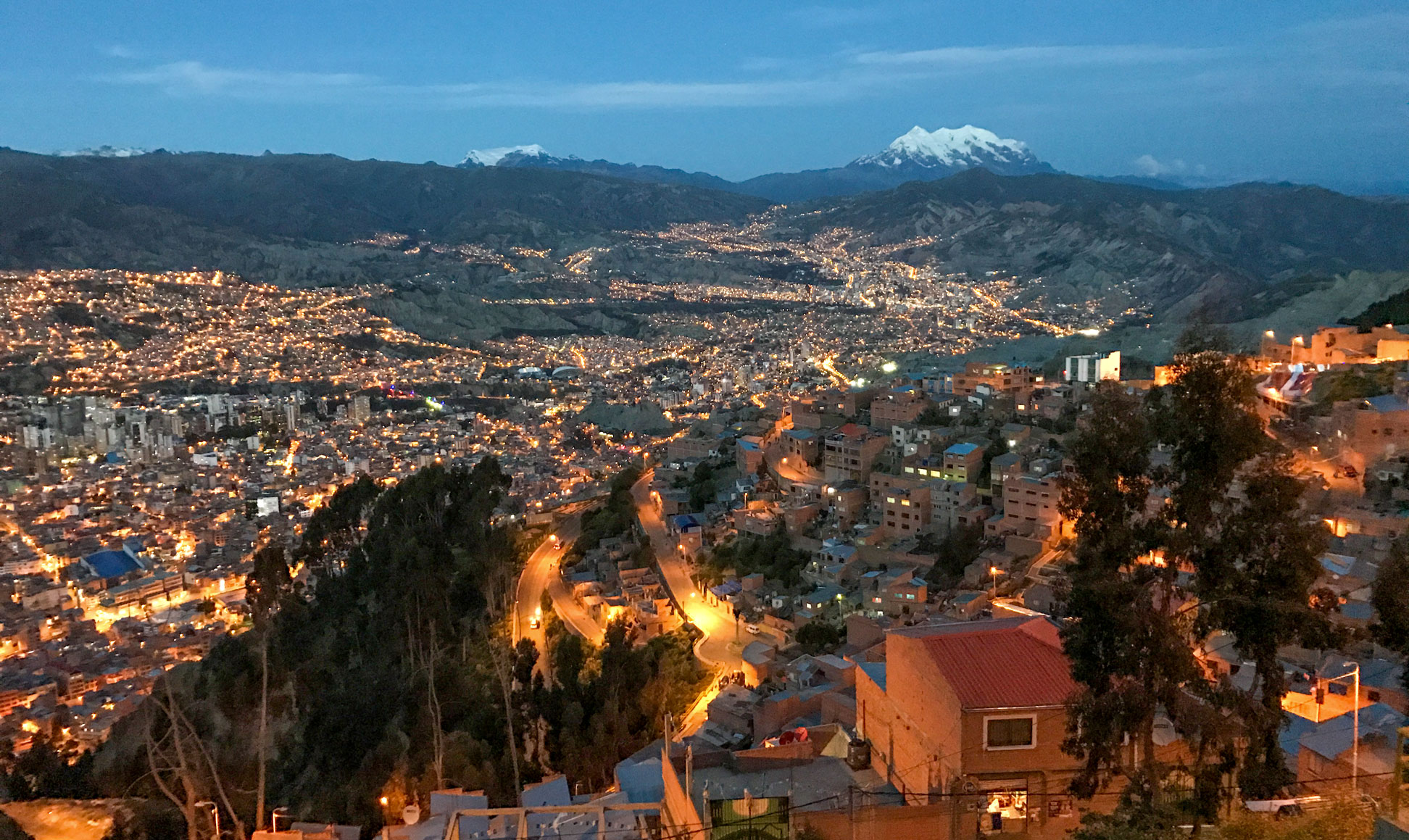
 Early evening in La Paz, one of the country's two capitals and the seat of the government. In the background is Illimani, at 6,438 m, the second-highest peak in Bolivia. The mountain is located about 40 km southeast of the city.
Image: Kyle Taylor
The western one-third of Bolivia's area is occupied by several mountain ranges of the Andes, the
Altiplano, the Andean high plateau with
Lake Titicaca, the salt flats of
Salar de Coipasa and
Salar de Uyuni, and the montane grass and scrubs land of the
Puna ecoregion. According to
PeakVisor, there are 3,780 named mountains in Bolivia.
There are four distinct mountain ranges: the western
Cordillera Occidental and the eastern
Cordillera Oriental; between them is the
Cordillera Real, east of
La Paz, and the
Cordillera Central, where the country's legislative capital
Sucre is located.
The highest mountains in Bolivia
- Nevado Sajama (6,542 m or 21,463 ft), the extinct stratovolcano within Sajama National Park in Bolivia's Sajama Province in the west, is the country's highest peak.
- Illimani (6,438 m or 21,122 ft), an extinct stratovolcano, is the highest mountain in the Cordillera Real (aka Cordillera de La Paz) and the second-highest mountain in Bolivia.
- Ancohuma (or Janq'u Uma; 6,427 m or 21,086 ft) is the third-highest mountain in Bolivia; it is located about 80 km (50 mi) northwest of La Paz in the Cordillera Real.
- Illampu (6,368 m or 20,892 ft) is located in the northern section of the Cordillera Real, just north of Ancohuma and east of Lake Titicaca.
- The Chiaraco, or Chiaroco, is a mountain in the Cordillera Real. It rises to 6,127 m (20,102 ft).
- Huayna Potosi, at 6,088 m or 19,974 ft, is located about 30 km (18 mi) north of La Paz.
- The Chachacomani is a 6,074 m (19,928 ft) high mountain in the Cordillera Real, located southeast of Lake Titicaca.
 Sky reflection in the Salar de Uyuni. The largest salt flat on earth (10,582 km²; 4,086 sq mi) is located on Bolivia's Altiplano plateau at an elevation of 3,656 m. [NASA]
Image: Danielle Pereira
Bolivia's major rivers originate in the glaciers of the Andes. Due to the country's topography, none of the rivers flows into the Pacific Ocean, but most of them into the Atlantic Ocean.
- On the Altiplano high plateau, there is an enclosed river system known as the TDPS System (Titicaca, Desaguadero, Poopó and Salares.
The Desaguadero River drains Lake Titicaca; it feeds Lake Uru Uru and then Lake Poopó; from there, a minor outlet leads to the salt flats (salares) of Coipasa and Uyuni.
The almost dried-up Lake Poopó was Bolivia's second-largest lake; its only visible outlet was the Lacajahuira River. During floods, it emptied into the Coipasa Salt Flat, some 80 km (50 mi) to the southwest. [EB]
- The Parapetí River has its source on the eastern side of the Andes; it flows through the Gran Chaco region of Bolivia and ends in the marshes and wetlands of the Bañados de Izozog depression.
- The rivers of the north and east, such as the Rio Beni, the Mamoré, the Madre de Dios, the Rio Grande (Guapay) and the Rio Guaporé (Iténez), flow through the lowland plains of the Amazon basin and empty into the Amazon River, South America's largest river.
- Bolivia's rivers in the south and southeast form the Pilcomayo-Paraguay river system, part of the much larger Río de la Plata drainage basin (River Plate Basin). The Pilcomayo River rises in the foothills of the Andes near the Bolivian city of Oruro. It flows southeastward through the Gran Chaco plains into the Paraguay River at Asunción, the capital city of Paraguay.
- Border rivers
The Rio Guaporé (Spanish: Río Iténez) flows into the Mamoré River which empties into the upper reaches of the Madeira River, together they form a long section of the northeastern Brazilian-Bolivian border. The Abuna River forms a section of the northwestern border to Brazil.
 Panorama of Potosí with Cerro Rico, a mountain known for its large silver deposits.
Photo: EEJCC
- Santa Cruz de la Sierra, aka Santa Cruz, is Bolivia's commercial center, the largest city and the capital of the Santa Cruz department.
- El Alto, Bolivia's second-largest city, is located west adjacent to the capital La Paz on the Altiplano highlands. El Alto is home to El Alto International Airport, Bolivia's main international airport.
- La Paz, officially Nuestra Señora de La Paz, is the seat of the Bolivian government. The city lies 3,650 m above sea level, making it the highest capital in the world.
- Cochabamba, the "City of Eternal Spring," is in central Bolivia. Together with the cities of Quillacollo and Sacaba, it forms the largest urban center between the capital La Paz and Santa Cruz de la Sierra in the tropical plains further east.
- Oruro (Uru Uru), the fifth largest city in Bolivia, is a mining town on the altiplano north of Lake Uru Uru.
- Tarija, the southern Bolivian city, is the capital of the Tarija Department. The largest city in southwestern Bolivia is known for its wine production.
- Potosí (Villa Imperial de Potosí), the capital of the Potosí department, is located about 4,000 m above sea level on the Altiplano plateau at the foot of Cerro Rico, a mountain known for its large silver deposits.
- Riberalta, the city in Bolivia's north, is known as the capital of the Bolivia's Amazon region.
International Airports in Bolivia
There are three international airports
in Bolivia.
El Alto International Airport (
IATA code: LPB), one of Bolivia's main international airports, is located in the city of El Alto, 13 km (8 mi) southwest of the administrative capital of La Paz. El Alto International is located at an altitude of 4,061 m (13,325 ft), making it the highest international airport in the world.
Aeropuerto Internacional de Alcantarí (IATA code: SRE) serves Sucre, the nation's constitutional capital city.
Jorge Wilstermann International Airport (IATA code: CBB) serves Cochabamba, the capital of the country's Cochabamba Department.
Viru Viru International Airport (IATA code: VVI) in Santa Cruz de la Sierra is Bolivia's largest international airport.
Climate
The coldest temperatures occur in the southwestern portion of the Altiplano during the winter months of June and July. The seasonal cycle of rainfall is marked, with the rainy season concentrated between December and March. The rest of the year tends to be dry, cool, windy and sunny.
The map shows the location of the following Bolivian cities and towns:
Abapo, Aiquile, Ascención, Atocha, Boyuibe, Camargo, Camiri, Caranavi, Challapata, Charana, Chivé, CobijaIxiamas, Cochabamba, Comanche, Concepción, Copacabana, Coro Coro, Corumbá, Cuevo, El Carmen, La Paz, La Quiaca, Magdalena, Montero, Oruro, Porvenir, Potosí, Puente, Puerto Suárez, Punata, Riberalta, Rio Mulatos, Roboré, Rurrenabaque, San Borja, San Cristóbal, San Ignacio de la Velasco, San José de Chiquitos, San Matías, San Miguel de la Velasco, San Pablo, Santa Ana, Santa Cruz de la Sierra, Sucre, Tarabuco, Tarija, Trinidad, Tupiza, Uncia, Uyuni, Villa Montes, Villazón, Yacuiba, Yapacani and Yucumo.
Advertisements:


