Nations Online
All Countries in the World
Nations Online All Countries in the World | |
Home  |
___ Satellite View and Map of Samoa |
Searchable Map and Satellite View of Samoa using Google Earth DataSatellite view is showing Samoa a group of islands in Polynesia in the South Pacific Ocean, divided betweenAmerican Samoa (pop.: 55,500) and the independent nation of (Western) Samoa (population: 186,000; 2011 census). Capital city is Apia. Spoken languages are Samoan and English (both official). The map shows Samoa with cities, towns, expressways, main roads and streets. To find a location use the form below. |
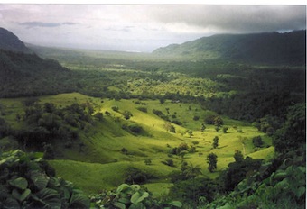 Falefa Valley at the east end of Upolu Island. Image: Kronocide |
| To find a location type: street or place, city, optional: state, country. | Local Time Samoa:
Wednsday-May-1 15:48
Time zone: West Samoa Time (WST) :: UTC/GMT +13 hoursDST from end of September until beginning April +14 hours |
|
φ Latitude, λ Longitude (of Map center; move the map to see coordinates): , |
||||||
| Google Maps: Searchable map/Satellite View and Map of the Independent State of Samoa. |
||||||
| More about Samoa: External links: Wikipedia: Apia | Current Weather Conditions Apia at Faleolo International Airport
|
Related Consumer Information:
|
||||
Other Polynesian Island Nations and Territories: American Samoa, Cook Islands, French Polynesia (Tahiti), Niue, Pitcairn, Tonga, Tuvalu |
||||||
| Countries and territories of Australia/Oceania Countries of the World: A - C | D - G | H - L | M - P | Q - T | U - Z Continents: Africa | The Americas | Asia | Europe |
||||||
Map Help [ show ] |
||||||
One World - Nations Online .:. let's care for this planet Promote that every nation assumes responsibility for our world. Nations Online Project is made to improve cross-cultural understanding and global awareness. More signal - less NOISE |
| Site Map
| Information Sources | Disclaimer | Copyright © 1998-2023 :: nationsonline.org |

