More about Cyprus
 View of the archaeological remains of Kourion – one of the island's most important city-kingdoms in antiquity. The site includes an Early Christian Basilica dating back to the 5th century CE.
Photo: A. Savin
View of the archaeological remains of Kourion – one of the island's most important city-kingdoms in antiquity. The site includes an Early Christian Basilica dating back to the 5th century CE.
Photo: A. Savin
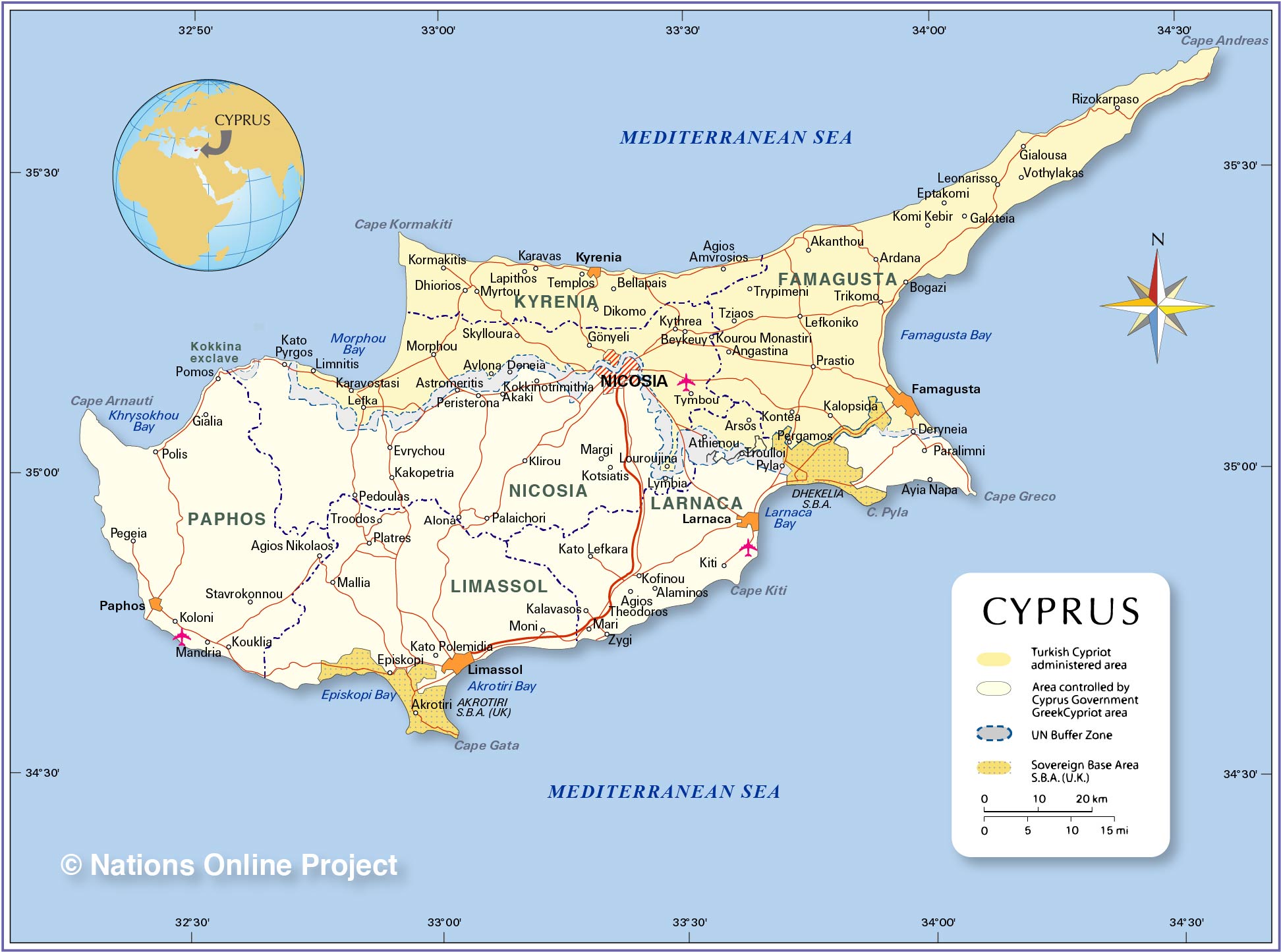
A United Nations peacekeeping force (UNFICYP) maintaines a buffer zone between both territoriies. UNFICYP was established in 1964 to prevent a recurrence of fighting between Greek Cypriots and the Turkish Cypriots. The mandate for UNFICYP was last renewed on 31 January 2019 and extends until 31 July 2019.
[1] [2]
Furthermore, there are two small British Overseas Territories on the island, Akrotiri and Dhekelia; they are administered as Sovereign Base Areas (S.B.A.) of the
United Kingdom. They are small remnants of British occupation of the island from 1878 to 1960.
Administrative divisions
Cyprus is divided into six districts:
Nicosia,
Larnaca,
Limassol and
Paphos in the Republic of Cyprus, and Famagusta and Kyrenia in the Northern Cyprus-controlled areas.
 View of Kyrenia from the castle. The city on the northern coast of Cyprus, is famous for its historic harbour and castle. Kyrenia is under control of the Turkish Republic of Northern Cyprus.
Photo: A. Savin
View of Kyrenia from the castle. The city on the northern coast of Cyprus, is famous for its historic harbour and castle. Kyrenia is under control of the Turkish Republic of Northern Cyprus.
Photo: A. Savin
The location of following cities, towns, and villages are
depicted on the map.
Republic of Cyprus
Agios Nikolaos, Agios Theodoros, Akaki, Alaminos, Alona, Astromeritis , Episkopi, Evrychou, Gialia, Kakopetria, Kalavasos, Kato Lefkara, Kato Polemidia, Kato Pyrgos, Kiti, Klirou, Kofinou, Kokkinotrimithia, Koloni, Kotsiatis, Kouklia, Larnaca, Limassol, Lymbia, Mallia, Mandria, Margi, Mari, Moni, Nicosia, Palaichori, Paphos, Pedoulas, Pegeia, Polis, Peristerona, Platres, Pomos, Stavrokonnou, Troodos, and Zygi.
Turkish Northern Cyprus
Agios Amvrosios, Akanthou, Angastina, Ardana, Arsos, Avlona, Bellapais, Beykeuy, Bogazi, Dhiorios, Dikomo, Eptakomi, Famagusta, Galateia, Gialousa, Gšnyeli, Kalopsida, Karavas, Karavostasi, Komi Kebir, Kontea, Kormakitis, Kourou Monastiri, Kyrenia, Kythrea, Lapithos, Lefka, Lefkoniko, Leonarisso, Limnitis, Louroujina, Morphou, Myrtou, Pergamos, Prastio, Rizokarpaso, Skylloura, Templos, Trikomo, Trypimeni, Tymbou, Tziaos (Chatos), and Vothylakas.
Within the UN Buffer Zone
Athienou, Deneia, Pyla, and Troulloi.
Within the Akrotiri Sovereign Base Area
Akrotiri
Transportation
There are three international airports in Cyprus.
✈ Larnaca International Airport - Glafcos Clerides
(IATA code: LCA), southwest of Larnaca;
✈ Paphos International Airport (IATA code: PFO), southeast of the city of Paphos in Western Cyprus;
✈ Ercan International Airport (IATA code: ECN) in north of Tymbou (Tymvou) in Northern Cyprus.
Official Websites
https://www.hermesairports.com
Hermes Airports manages and controls Larnaka International Airport and Pafos International Airport.
Ercan Airport
Website of Ercan Airport (T&T Ercan Airport).


 You are free to
use above map for educational purposes, please refer to the Nations Online Project.
You are free to
use above map for educational purposes, please refer to the Nations Online Project. 


